Style

Thirteen days in October, from Ann Arbor and back, through upstate New York, Vermont, Maine and New Hampshire. Lighthouses on the Maine coast, the White Mountains in full color, Vermont back roads, sunset at Niagara Falls, and a lot of good food along the way. Every shot below sits where its GPS says it was taken.

Greetings from

NEWENGLAND

October 1 to 13, 2026  ·  Ann Arbor and back

Thirteen days in October, from Ann Arbor and back, through upstate New York, Vermont, Maine and New Hampshire. Lighthouses on the Maine coast, the White Mountains in full color, Vermont back roads, sunset at Niagara Falls, and a lot of good food along the way. Every shot below sits where its GPS says it was taken.

A field guide · October 1 to 13, 2026

New England, in leaf

Thirteen days from Ann Arbor and back. Each column is one day, colored with the brightest leaves in the landscape shots from that day. Hatched columns are days whose photos had no bright fall color. Tap a column to jump to that day.

Foliage by dayBand height = share of leaf color
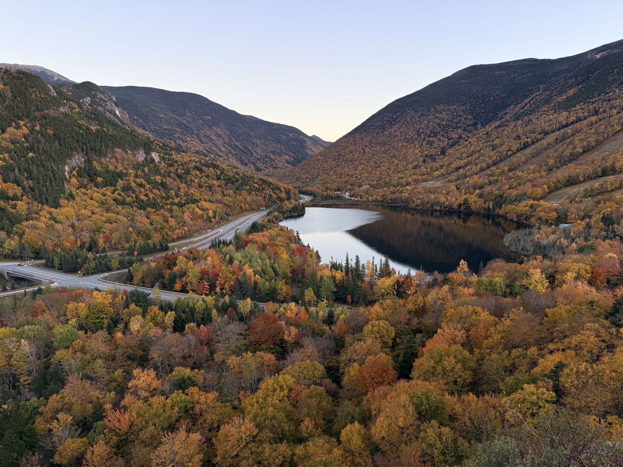
Artist's Bluff. Echo Lake and Franconia Notch at sunset, with I-93 threading through.
Artist's Bluff Echo Lake and Franconia Notch at sunset, with I-93 threading through. Day 8, 6:10 PM.
Days
13
States photographed
4
Lighthouses
3
Photos
38
Clips
15
Food and drink shots
12
Highest shot, On the Cog Railway
3,100 ft

The route

The red line runs through every photo and clip in the order they were taken. Dashed lines are drives with no photos, out of Ann Arbor on the first day and back home on the last. Green markers sit at the main stop of each day; tap one to jump to that day.

Route map Map from Ann Arbor across upstate New York, Vermont, New Hampshire and Maine, with the trip path through every photo location in order, dashed drives with no photos to and from Ann Arbor, and numbered markers for each day. MAINE MASSACHUSETTS MICHIGAN NEW HAMPSHIRE NEW YORK PENNSYLVANIA VERMONT CANADA White Mountains Ann Arbor start and finish Buffalo Syracuse Albany Woodford Portland Acadia Bangor Granville Gulf Warren Hill Farmstead Lake Willoughby Lake Placid Skaneateles Niagara Falls Dunkirk 1 2 3 4 5 6 7 8 9 10 11 12 13

Drag the map to see the rest of the loop, back to Ann Arbor.

Elevation of every shot

GPS elevation recorded in each file, by day and time of day.

Elevation of every shot Each dot is one photo or clip, placed by day and time, at the GPS elevation recorded in the file. Highest: On the Cog Railway, 3,100 ft. Lowest: Frazer Point, Schoodic, 0 ft. 0 ft 1K 2K 3K 1 2 3 4 5 6 7 8 9 10 11 12 13 DAY On the Cog Railway · 3,100 ft Frazer Point, Schoodic · 0 ft

The reel

1:48, start to finish, in the order it was shot, food included.

Day 1

Ann Arbor to Buffalo

Michigan to New York

No fall color in frame

The drive out of Ann Arbor, with the first night in Buffalo.

Buffalo, first night A house in the neighborhood already all in on Halloween: giant skeletons, a pumpkin-headed figure, purple and green lights.700 ft42.80° N, 78.78° W

Day 2

Buffalo to Albany

New York, by way of Syracuse

No fall color in frame
EatsDinosaur Bar-B-Que, Syracuse On the specials board: a Jucy Lucy burger and The Three Little Pigs.400 ft43.05° N, 76.15° W
EatsDinner in Albany Fried calamari with pickled peppers.230 ft42.65° N, 73.79° W

Day 3

Albany to Portland, across Vermont on Route 9

New York, Vermont, Maine

The day in leaf color
Albany, early morning A Victorian porch with the flag out, before the drive east.240 ft42.66° N, 73.81° W
Adams Reservoir, Woodford State Park Mist coming off the water at 8 in the morning, about 2,300 feet up on VT 9.2,300 ft42.89° N, 73.04° W
Woodford State Park Picnic tables, peak color, and the reservoir still steaming.2,320 ft42.89° N, 73.04° W
Woodford State Park Morning sun through the maples, with mist still on the water.2,330 ft42.89° N, 73.04° W
Woodford State Park A leaf-covered trail and footbridge along the reservoir.2,330 ft42.89° N, 73.04° W
EatsLobster ramen, Portland Ramen topped with a lobster tail, a soft egg, corn, bok choy and scallions, with edamame on the side.130 ft43.65° N, 70.27° W
EatsPortland, Maine Special today: lobster gelato. Brown butter gelato with pieces of steamed Maine lobster.30 ft43.66° N, 70.25° W
Portland Head Light Cape Elizabeth, late afternoon.30 ft43.62° N, 70.21° W
EatsFries, Portland A paper cone of fries with five dipping sauces.10 ft43.66° N, 70.25° W

Day 4

Lobster roll in Gray

Maine

No fall color in frame
EatsGray, Maine Lobster roll with sweet potato fries.280 ft43.88° N, 70.33° W

Day 5

Thunder Hole and Jordan Pond

Acadia National Park, Maine

The day in leaf color
Thunder Hole Waves surging into the chasm on the Park Loop Road, Acadia National Park.80 ft44.32° N, 68.19° W
The Bubbles, Jordan Pond The twin peaks at the north end of Jordan Pond, seen from the south shore.280 ft44.32° N, 68.25° W
Jordan Pond Red leaves and tall pines along the shore, Acadia National Park.270 ft44.34° N, 68.25° W
Jordan Pond Forty minutes later, with the clouds in and red shrubs along the shore.290 ft44.33° N, 68.26° W

Day 6

Schoodic, Bangor and Bass Harbor

Maine

No fall color in frame
Frazer Point, Schoodic The dock at Frazer Point on a bright, windy morning, in the Schoodic section of Acadia.0 ft44.38° N, 68.08° W
EatsBangor Brownie sundae.50 ft44.79° N, 68.78° W
Bass Harbor Afterglow over the water, a few minutes after sunset.10 ft44.22° N, 68.34° W
Bass Harbor Head Light The lamp lit on the pink granite cliff at dusk.10 ft44.22° N, 68.34° W

Day 7

The Kancamagus

White Mountains, New Hampshire

The day in leaf color
Swift River Boulders and color along the Kancamagus Highway.960 ft44.02° N, 71.25° W
Falls Pond, Rocky Gorge Still water and reflections just off the Kancamagus.1,130 ft44.00° N, 71.28° W

Day 8

Mount Washington to Franconia Notch

White Mountains, New Hampshire

The day in leaf color
Mount Washington Cog Railway Base station at about 2,700 feet, with the summit in the clouds.2,690 ft44.27° N, 71.35° W
On the Cog Railway Looking along the track at about 3,100 feet, through red and orange alpine scrub.3,100 ft44.27° N, 71.34° W
Mount Washington The Cog Railway line climbing into the clouds, with a train on the track.2,660 ft44.27° N, 71.35° W
Below Mount Washington Yellow and red on both sides, and one big cumulus over the road.2,290 ft44.27° N, 71.37° W
Bretton Woods Across the golf course at the Mount Washington Hotel.1,660 ft44.26° N, 71.44° W
The Flume View from the Flume Gorge loop, Franconia Notch State Park.1,570 ft44.10° N, 71.67° W
The Flume Fallen leaves over a web of roots on the trail.1,170 ft44.09° N, 71.68° W
Echo Lake Cannon Mountain and its ski trails reflected in the lake.1,920 ft44.18° N, 71.69° W
Artist's Bluff On the rocks above Echo Lake at sunset.2,160 ft44.18° N, 71.70° W
Artist's Bluff Echo Lake and Franconia Notch at sunset, with I-93 threading through.2,150 ft44.18° N, 71.70° W
EatsPB&J burger, Common Man A PB&J burger with fries and a pickle at the Common Man in Lincoln, New Hampshire.880 ft44.05° N, 71.66° W

Day 9

Campton to Granville Gulf

New Hampshire, Vermont

The day in leaf color
Campton, New Hampshire Morning in the Pemigewasset valley.630 ft43.85° N, 71.64° W
Granville Gulf, VT 100 Last light on the ridge at the top of the gulf.1,210 ft44.02° N, 72.85° W

Day 10

Warren to Lake Willoughby and Hill Farmstead

Mad River Valley and Northeast Kingdom, Vermont

The day in leaf color
Hostel Tevere, Warren House rules, framed: if your feet are real dirty, please leave.820 ft44.13° N, 72.85° W
Hostel Tevere, Warren Donnelly's Excellent Cooking Operation.820 ft44.13° N, 72.85° W
Warren, Vermont A baby blue McLaren parked out front.820 ft44.13° N, 72.85° W
Lake Willoughby From above the south end of the lake.1,410 ft44.72° N, 72.03° W
Lake Willoughby, south beach Under the cliffs of Mount Pisgah.1,170 ft44.72° N, 72.03° W
Lake Willoughby, north end Looking down the lake to Willoughby Gap.1,160 ft44.78° N, 72.07° W
Hill Farmstead Brewery The mascot on the wall at Greensboro Bend.1,690 ft44.61° N, 72.26° W
Northeast Kingdom Dirt roads at dusk.1,690 ft44.59° N, 72.27° W

Day 11

Warren to Lake Placid

Vermont, Adirondacks, New York

The day in leaf color
EatsThe Hill Farmstead haul Of First and Last Things, Holger Danske and Abner, packed for the road.820 ft44.13° N, 72.85° W
Mirror Lake, Lake Placid A gray afternoon and a perfect reflection.1,830 ft44.29° N, 73.98° W
EatsEmma's Lake Placid Creamery The sign over the case says it all: eat more ice cream.1,880 ft44.29° N, 73.99° W
Mirror Lake, Lake Placid Adirondack peaks under a low, heavy sky.1,860 ft44.29° N, 73.98° W

Day 12

Skaneateles to Niagara Falls and Duff's

New York

No fall color in frame
Skaneateles Eat fish, live longer. A Doug's Fish Fry sticker downtown.890 ft42.95° N, 76.43° W
Niagara Falls The American Falls at sunset, the Ontario skyline behind.420 ft43.09° N, 79.07° W
EatsDuff's Famous Wings, Amherst Buffalo wings near Buffalo, with blue cheese, celery and carrots.620 ft42.98° N, 78.80° W

Day 13

Wingnutz, Lake Erie, and home

New York to Michigan

No fall color in frame
EatsWingnutz, Williamsville A wing flight: a board of wings in a run of different sauces.590 ft42.99° N, 78.79° W
Dunkirk Lighthouse Point Gratiot, on the Lake Erie shore.600 ft42.49° N, 79.35° W

Then the drive home to Ann Arbor.

Naresh smiling under yellow and orange maples

End of the road

Back home in Ann Arbor on October 13.

Photos and clips by Naresh.